Prairie Creek Preserve
Accessibility Information
Parking Lot Description
The Prairie Creek Lodge Trailhead
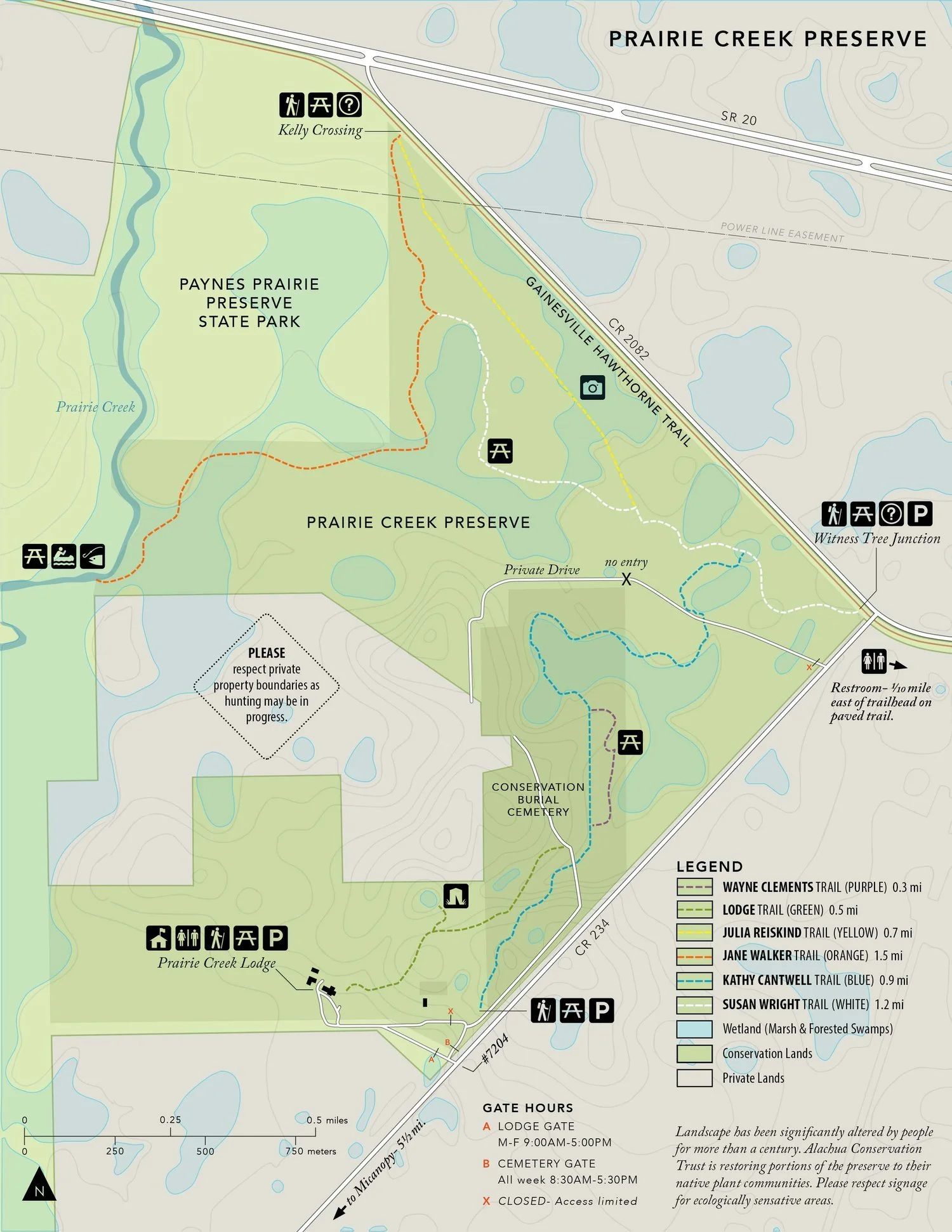
The Prairie Creek Lodge trailhead has a parking lot of mowed grass. There are no kiosks or picnic tables, however, visitors can find a map and restrooms inside the front door of the building. An accessible restroom can be found on the Western side of the Lodge in the offices of Prairie Creek Conservation Cemetery.
The Kathy Cantwell Trailhead
The Kathy Cantwell trailhead parking area is grass that is mowed regularly. There is an informational kiosk with printed maps and a shaded picnic table (non-accessible) 100 feet from the parking area. There are no restrooms, water fountains, or trash cans.
The Witness Tree Junction Trailhead
The Witness Tree Junction trailhead parking area is a mixture of grass and dirt and provides access to both Prairie Creek Preserve and the Gainesville Hawthorne Rail Trail. The trailhead has an informational kiosk with printed maps, an accessible picnic table, a bike rack, and a bike repair station.
There is an accessible Restroom 1/10 of a mile East of the trailhead on the paved bike trail.
The Kelly Crossing Trailhead
The Kelly Crossing trailhead has an informational kiosk with printed maps, a picnic table (non-accessible), a covered bench, and a bike rack. There is no parking, restrooms, water, or trash cans.
Kathy Cantwell Trail (Blue)
Trail Length: 1.4 miles
Steepest slope: 5%
Total elevation gain: 45 feet
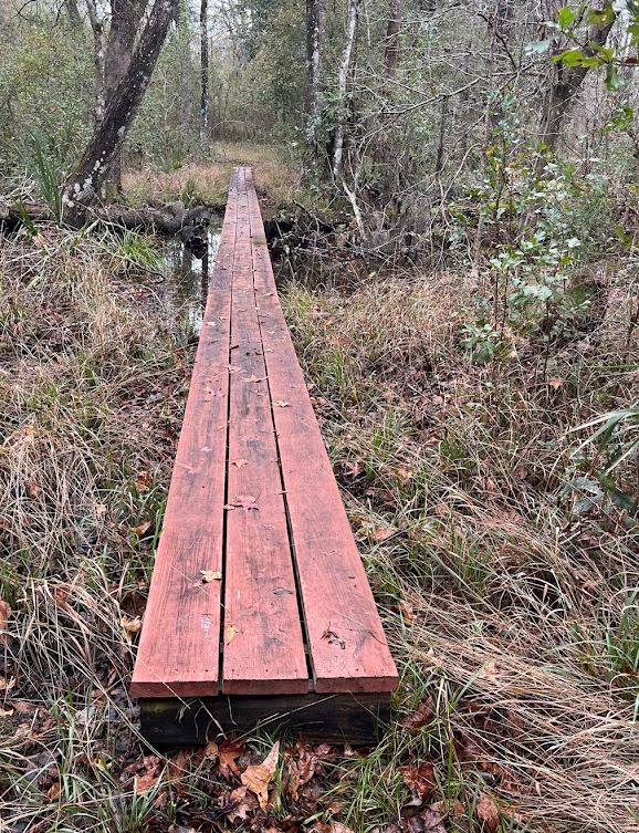
The Kathy Cantwell Trail (Blue) starts as a mowed grass trail for the first 200 feet and then transitions into a surface primarily made up of dirt and leaf litter. Various roots are protruding in the trail, with some being as large as 2 inches. The tree canopy is made up of live oaks, pignut hickory, sweetgum, and other hardwood trees. The average trail width is 5 feet. There is a depression 0.15 miles into the trail that contains a small footbridge.
The trail comes out onto Cemetery Lane where it crosses a dirt road and then continues through the woods, winding through oak hammock and palmettos, hugging the eastern part of Prairie Creek Conservation Cemetery. The trail is mostly compact in this area, with a few small areas of looser dirt.
A side trail, the Wayne Clements Trail (Purple) is located 0.4 miles into the trail and takes you 0.3 miles to the East to a picnic area with two tables (non-accessible) before returning to the Kathy Cantwell Trail.
The Blue trail winds slightly downhill towards a wetland and several large roots are on the trail, leading to an 80-foot-long footbridge that is 2 feet wide. ACT plans on replacing this bridge in 2024 with a 4-foot wide bridge with ramps. This takes you over a wetland. The trail for the next quarter mile hugs a wetland and can be very muddy and soft depending on rain, eventually leading to a 16-foot-long bridge that is 4 feet wide over a creek with a handrail. ACT plans on adding ramps to this bridge soon.
The trail cuts across a former slash pine plantation that is managed with prescribed fire every 3-4 years and has been re-planted with longleaf pine. There are palmetto stumps that protrude in some areas and the trail traverses some pine planting beds that give the effect of going over several small hills every 10 feet before exiting across another 12-foot-long bridge that is 4-foot wide with minor ramps.
The trail crosses a dirt road, continuing down a mowed grassy trail for 200 feet before cutting downhill towards the border between upland pine and a wetland. The trail for the next 0.25 miles is often wet, and soft, and contains numerous roots before ending at the Susan Wright Trail (White), where the trail goes West towards Prairie Creek or East towards the Witness Tree Junction trailhead parking area.
Susan Wright Trail (White)
Trail Length:1.2 miles
Steepest slope: 1%
Total elevation gain: 14 feet
The Susan Wright Trail (White) begins at the Witness Tree Junction in Rochelle. The trail is a mixture of mowed grass and dirt and is mostly very firm. Portions of the trail will be wet or slightly underwater during rainy periods. 0.1 Miles into the trail there is a 4-foot wide footbridge with ramps that is 266 feet long and 2 feet above the ground. The trail continues for another 0.1 miles before coming to a swamp. The trail goes over a 144-foot-long footbridge that is 2 feet wide before exiting onto a dirt surface. ACT plans on replacing this with a 4-foot wide bridge in 2024. At 0.5 miles, the trail comes to a junction where users can turn right onto the Julia Reiskind Trail (Yellow) or continue on the white trail. The remainder of the trail passes through pine flatwoods that are burned regularly and some lower edges of wetlands before terminating at the Jane Walker Trail (Orange).
Julia Reiskind Trail (Yellow)
Trail Length: 0.7 miles
Steepest slope: 1%
Total elevation gain: 3 feet
The Julia Reiskind Trail (Yellow) can be accessed from the Kelly Crossing Trailhead along the Gainesville Hawthorne Trail. The trail is a combination of dirt and mowed grass with very few protruding roots. 0.15 miles from the trailhead there is a depression that often holds water and a side foot bridge for crossing. 0.25 miles from the trailhead is a covered wildlife blind with a ramp leading up to it. The ramp is 4 feet wide and has a slope of x. The trail terminates at the Susan Wright Trail (White).
Jane Walker Trail (Orange)
Trail Length: 1.5 miles
Steepest slope: 1%
Total elevation gain: 3 feet
The Jane Walker Trail (Orange) can be accessed from the Kelly Crossing Trailhead along the Gainesville Hawthorne Trail. The trail surface is dirt and leaf litter with roots in various locations. At 0.1 miles, the trail cuts across an old berm that is 2-3 feet wide with several large roots and then crosses a powerline easement that is frequently wet and soft. 0.15 miles in is a small footbridge with no ramp. ACT will be adding a ramp to this in the near future. The trail slowly slopes downward into a bottomland forest with many hardwood trees. At 0.15 miles, there is a creek crossing and a small 1-foot wide footbridge. At 0.6 miles, trial users step up onto a 2-foot wide footbridge that winds through a cypress swamp for 0.9 miles. A quarter mile after the bridge ends, the trail ends at Prairie Creek where a picnic table is also located.
Lodge Trail (Green)
Trail Length: 0.5 miles
Steepest slope: 2%
Total elevation gain: 4 feet
The Lodge Trail (Green) can be accessed from the Prairie Creek Lodge parking area. The trail is a dirt and mowed grass surface that transitions to dirt and leaf litter as the trail progresses. The trail climbs slowly with a few small areas of looser dirt. At 0.15 miles, a side trail takes users to a wildlife blind with a view of a pond. The trail then continues, slowly sloping downhill before terminating in Prairie Creek Conservation Cemetery. Trail users can take a right and follow the road to the Kathy Cantwell Trail (Blue).
Contact ACT for more information or comments about our accessibility of our preserves by calling (352)373-1078 or emailing info@alachuaconservationtrust.org


